
Lebanon to Pollock
 ABOUT THE ROUTE
For an authentic experience of early Ohio, make Lebanon your base for the upper Miami watershed or even all of southwest Ohio. The legendary Golden Lamb Inn downtown is Ohio’s oldest continuously operating business; its 18 guest rooms have many stories to tell, having hosted many presidents and other distinguished guests. Along well-preserved, tree-lined downtown streets are many cafés, antique and specialty shops, and other amenities. On weekends, a scenic railroad tour embarks from the nearby station for Mason and Monroe. Two blocks from the Golden Lamb is one of Ohio’s finest Greek Revival mansions, open as a museum: “Glendower” was built in 1840 for one of the framers of the state’s constitution, and has exceptional architectural details.
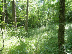
The Pollock earthwork's gateways lie buried in the forest.
 WAYNESVILLE TO YELLOW SPRINGS
Northeast of Lebanon (9 miles along US 42) is Waynesville. Clustered along its well-preserved Main Street are many antique and specialty shops. This is a major destination for antique and furniture buyers, with more than fifty dealers including some with various specialties. Continue on US 42 for 15 miles to downtown Xenia. In a new subdivision in the northwestern part of Xenia, the Kinsey Road Mound stands preserved in a small park. It is a rare example of an Adena era mound still together with its surrounding ring. Beyond along US 42 lies the town of Wilberforce, home of the university of the same name founded in 1856 by and for African Americans, the first of its kind in the country. From here, back roads toward Yellow Springs include and excellent covered bridge. Or, from Xenia, take US 68 north for 11 miles to Yellow Springs, a picturesque college town and former spa, and home to the recently-revived Antioch University. Near Yellow Springs, Glen Helen Park and John Bryan State Park offer excellent recreational opportunities including hiking and bike trails, waterfalls, a covered bridge, and a mound.
An excursion north from Yellow Springs will take you to Enon Mound, a large Adena era burial structure now at the heart of an aptly-named suburban district and encircled by a narrow lane. From Yellow Springs it is also a short drive into metropolitan Dayton (see Dayton page).
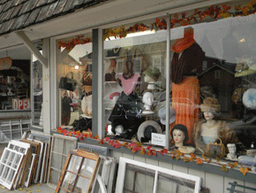
Nearly anything that’s old is available among Waynesville’s many antique and specialty shops.
 CLIFTON GORGE
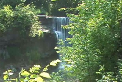
Clifton Gorge is especially spectacular and is reached from South Jackson Street in the tiny village of Clifton (4 miles east of Yellow Springs via SR 343). A narrow canyon of the Little Miami River is framed by 110-foot, vertical limestone cliffs. This crevice, surrounded by towering 300-year-old trees, seems especially surprising in this otherwise only slightly-rolling agricultural landscape; its microclimates shelter rare plants and wildflowers. Trails lead along the rim and down to the bottom where they wander among huge boulders. Rushing waterfalls display the concentrated power of the river here, harnessed in the early 1800s by several industrial operations. Clifton Gorge was once named by National Geographic as one of the nation’s 50 most beautiful places.
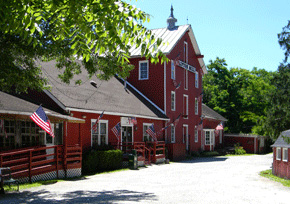
Still standing above the gorge is historic Clifton Mill, among America’s oldest and largest surviving water-powered grist mills, and home to the Millrace Restaurant.
 POLLOCK EARTHWORKS
Leave Clifton village by SR 72 going south 4 miles to Cedarville. Turn right on US 42 and in about 1.4 miles, a log cabin will appear on the right, at the parking area for Indian Mound Park. A walking trail leads across Massie’s Creek, then along the stream and up the hill to the left to reach the large, conical, Adena era Williamson Mound at the peak of the hill.
Also from the parking area, a marked trail heads east to the Hopewell-era earthworks, where walls and gateways enclose the western end of a prominent limestone plateau. In about 600 feet, a series of earthen walls and gateways appear: though densely covered with growth, it is clear when the path rises that you are passing through one of the site’s three major gateways.
On its other three sides, the plateau is surrounded by often dramatic, sheer stone cliffs. Wooded trails lead past rock shelters where many ancient remains have been found, alongside evidence of early 20th century quarrying and abandoned industrial waterworks.
Massie’s Creek enters a narrow gorge just outside Cedarville, Ohio. On a limestone plateau, surrounded by two ancient courses of the river, are a series of earthen walls and gateways. Here, archaeologist Robert Riordan, of Wright State University, has unearthed the story of a hilltop, gated with stone and earth, briefly protected by a high wooden stockade, which was then burned by its builders in a great crescent of fire.
Play video
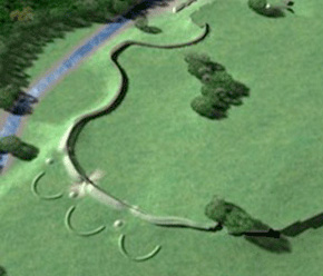
The original Pollock Earthworks as shown in this model enclose the western end of an otherwise sheer-rock plateau surrounded by Massie’s Creek (CERHAS University of Cincinnati).
 CONSTRUCTION SEQUENCE AND BIG FIRE
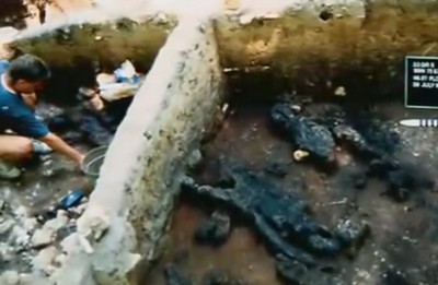
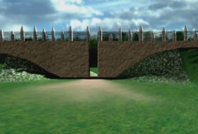
By cutting several trenches through the wall, Dr. Riordan and his students have been able to uncover the phases of construction that went on here. Around the first century AD, a low embankment was laid across between the creek bluff and the start of the limestone cliff. It was about 300 feet long, with a gateway in the center. Then, over about a hundred years, they made two separate additions to the wall, making it higher and leaving two more gateways. The most remarkable phase was the building of a huge timber fence, or stockade, along the earthen wall, and way out along the northern bluff.
The big fire that consumed the stockade was part of a pattern of Hopewell people burning things: returning them to ash and smoke, to the earth and sky. Dr. Riordan found evidence for this fire in one of his excavation trenches, showing how they had also buried the charred remains, extending a small embankment out along the northern bluff. As often with the Hopewell, burying followed burning. This returned the site to its original architectural treatment, with only earthen walls.
The earthen walls stand only at the end of the plateau that’s not already surrounded by high cliffs. Like other hilltops, the theme here is “enclosure,” either to keep something out, or something in. They were carefully built. Before anything was done, a thin layer of clay was laid down, to prepare the surface. The outside surface contained a lot of stone; and the gateway passages were also paved and lined with limestone blocks. Walking the site today, the walls seem quite large, yet they stood even higher in antiquity: Erosion has filled in the area behind them by about three feet.
 MODERN USES, EXCAVATIONS
On the hilltop to-day, the trees are small, reminding us this was farmland up here until the 1960s. An old paper mill used the stream, and built big holding ponds down below to try to reduce their pollution. Just outside the ancient gateways there was a limestone quarry. Blasting marks are still visible along the southern cliff. Quarrying is probably what destroyed the crescents. For decades now it has been a Greene County Park; and Wright State University’s archaeology field school began regular investigations here in 1981.
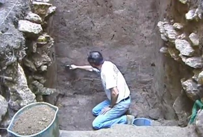
Dr. Riordan has made some very exciting discoveries here at the Pollock Works, but it took nearly twenty years of work. Modern archaeology is a very meticulous process. Deciding where to dig is done with great care, since it is rare that an entire site can ever be excavated. Trenches are laid out on an exact grid. Layers of soil are removed very carefully; and everything that’s found is recorded: drawn, photographed, numbered, tagged, stored, and dated.
Archaeologists don’t always get the chance to do the detailed work that makes their discoveries meaningful and reliable. Many sites in Ohio still have private owners who can refuse to give archaeologists access, or who let the ancient places deteriorate, or get bulldozed. Luckily, the Pollock Works became a Greene County park, helping to make Doctor Riordan’s careful, sustained efforts possible.
The four crescents on Squier and Davis’ plan are now only a mystery. Architectural historian John Hancock:
Often in making our computer models, we found we couldn’t match the old drawings with what we knew was out there, or what we could see on aerial photographs. In the case of these four crescents, for example, the one that Squier and Davis drew over farthest to the north, would have been floating out above the river!
But Samuel Owens, the county surveyor, had only shown two crescents in 1842; and Davis himself, though he described four, had located one in front of another on his field notes.
With these surveyors, I think it was sometimes a question of what they remembered when they got back to the hotel room, or what their engraver thought would look nice on the map!
In any case, the crescents were small, under three feet high. And like the little stone mounds between them, they disappeared long ago.
Nearby, 3 ½ miles southwest along SR 42, is Wilberforce, home to Wilberforce University, founded in 1856 and the first institution of higher learning to be owned and operated by African Americans, whose faculty and alumni have included many distinguished leaders and scholars. Half a mile west of SR 42 is the National Afro-American Museum and Cultural Center (1350 Brush Row Road, 800-BLK-HIST), a state-sponsored museum in a striking new building. Call before visiting: heating and air conditioning problems have caused some closures.