
Fort Hill
 ABOUT THE ROUTE
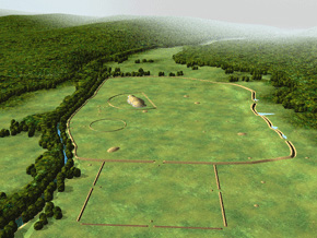
Between Serpent Mound and the Paint Creek Valley is one of the region’s most spectacular natural and architectural treasures, Fort Hill. Owned by the Ohio Historical Society and operated by the Arc of Appalachia Preserve System, this 33-acre, earthwork-enclosed plateau stands exactly where an amazing variety of geological and ecological zones converge. The massive, sandstone-paved, Hopewell-era earthwork (ca. AD 200) stands today within a huge nature preserve, amidst one of the largest old-growth forests in the Midwest.
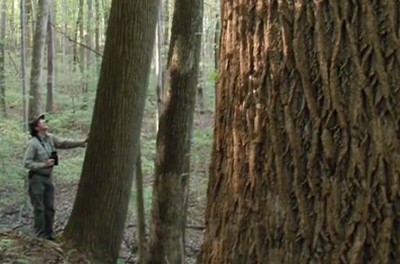
The park is a remarkable convergence of ecosystems; rare plant and animal life thrives in conditions which seem, amazingly, to vary from one side of the hill to another. Micro-climates, plus soil and bedrock conditions around the hilltop and in the surrounding ravines, produce a startling variety: most spectacular are the spring wildflowers, and surviving pre-glacial species like the Canadian White Cedar. The steep hillsides, the earthworks, streams, gorges, and dense old-growth forest can be explored along 11 miles of hiking trails, of varying length and difficulty, all diverging from the peaceful picnic area, just above the museum.
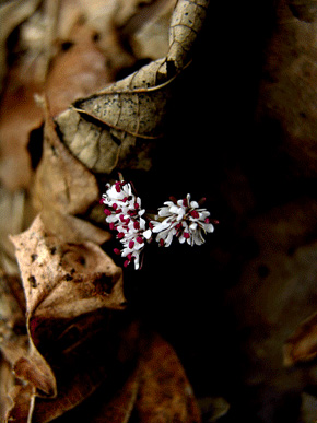
April wildflowers; over 800 plant species have been recorded within Fort Hill’s 1200 acre nature preserve.
The site’s address is 13614 Fort Hill Road, Hillsboro, OH 45133; phone: 937-588-3221. Contact the Arc of Appalachia or visit their website (www.arcofappalachia.org) for opening times.
 THE FORT HILL MUSEUM
A small museum presents the geology, zoology, and archaeology of the site. Exhibits portray the remarkable fact that four of Ohio’s five major geological zones converge here: the Till Plains, the Glaciated Hills, the Unglaciated Appalachian Plateau, and the Lexington (or Bluegrass) plains coming up out of Kentucky. Other displays explain the diverse flora (especially flowers and exotic plants) and the conditions that support them, plus the fauna (especially birds) of the area. Model reconstructions depict the “arbor” underneath the Hopewell-era earthen ring, and the large ceremonial building, both discovered in the 1950s in a meadow just south of the site.
A sunlit contour model of Fort Hill adorns the entrance to the site’s museum.
 THE PICNIC AREA
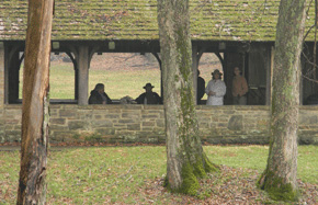
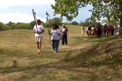
Home base for Fort Hill hiking is the beautiful picnic area, with its tree-shaded parking lot, small stream, and well-proportioned stone and timber structures, erected here in the 1930s by the Civilian Conservation Corps. These and similar structures at other archaeological sites were part of the public outreach and facility enhancement initiatives by Henry Shetrone, the former newspaper reporter who was then Curator of Archaeology at the Ohio Historical Society.
From here the various trails diverge: The Fort Trail heads south, from where it offers good views of the earthworks from below as it approaches the southeastern Gateway. Beyond that, the long, strenuous Gorge Trail leads to stone cliffs and arches, and a picturesque log cabin shelter. Leaving directly from the edge of the parking lot, the Earthwork Trail makes the steep, 360-foot vertical climb to the northern “prow” of the plateau, encircled by the North Gate of the earthwork.
 NORTH GATE
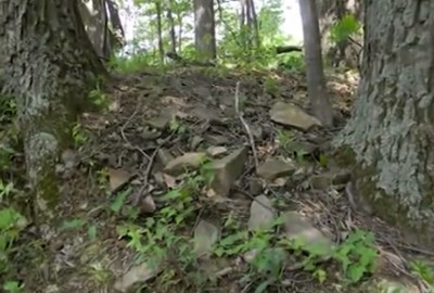
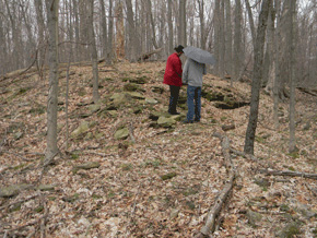
Near the top of the steep Earthwork Trail, the pathway becomes strewn with huge sandstone blocks and passes through one of the earthwork’s 33 gateways. Inside, the natural plateau comes to a sharp point, with the earthwork rimming it on three sides. These giant walls were built nearly 2000 years ago, to enclose the entire level hilltop with a system of ditches, walls, pavements, and gates. This half-mile perimeter includes three other especially dramatic “prow” shapes, like this northern one.
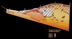
The walls were built in three stages and made extensive use of sandstone for both ballast and paving.
 WALL CONSTRUCTION
Giant old-growth trees now cover the Fort Hill earthwork. Tangled among their roots are masses of now-broken sandstone slabs, once part of an elaborate construction process. Retired Ohio Historical Society Curator Martha Otto explains:
There was work done there in the 1960s to investigate a section of the wall, and to determine that there was an inner core of blocks of stone, in kind of a triangular shape, and then to provide the ballast for the wall itself. So it wasn’t just a bunch of earth piled up, but there was an intentional plan for making sure that the wall would be secure and stay in place. In fact, it has for two thousand years.
Two parallel walls were built, around the rim of the plateau, with both earth and stone. Then both were capped and unified by the final layer, up to 15 feet high, and surfaced with carefully shaped and fitted sandstone slabs, taken from the top of the plateau.
 POND AND EAST GATE
A rugged trail follows the eastern flank of the earthworks and approaches near a large pond, often brimming with frogs and distinctive plant life. Beyond, the eastern prow of the earthwork is marked by a cascade of worked, sandstone slabs, one of the best spots to appreciate the extensive role of stone in this architectural design.
To appreciate the scope of this achievement, stand at the edge of the natural plateau and look down the slope into the ditch: imagine that surface continuing down the hill. Everything standing before you is a massive construction of earth and stone.
Near the eastern gateway a cascade of ancient, worked paving stones is especially prominient.
 SOUTH WALL
The Earthwork Trail follows the long western flank of the hilltop, with several especially prominent gateways, before the sharp turn at the southwestern corner (the trail drops through here to descend and meet the Gorge Trail). The especially monumental southern flank of the earthwork overlooks the trails below, and culminates in another projecting prow to the southeast, aiming out towards the park’s southern meadow, where ancient ceremonies and workshops were located.
Like other Hopewell-era hilltop enclosures, there is no evidence of warfare, or defensive requirements. Instead, this artificially-encircled hilltop was about some other purpose.
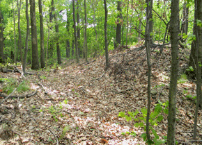
The wall and ditch along the western side of the hilltop earthwork.
 CIRCULAR EARTHWORK
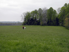
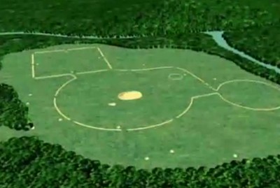
Below the southern prow of the earthwork, the park’s trails diverge. A piece of Ohio’s Buckeye Trail (a system that criss-crosses much of the state) heads south and opens out into a meadow, with a large barn. To the right lies one of the ghostliest treasures in all of Ohio: visible on Google-Earth, and still here, at the edge of the meadow, is a beautifully preserved, ancient earthen ring. This is probably the best kept of the several hundred that were recorded during the 19th century.
It was partially excavated by Ohio Historical Society archaeologist Ray Baby (BAH-bee) in 1953. His exploratory trenches revealed a double ring of posts, 174 feet in diameter – he called it an “arbor”. A possible reconstruction, as well as details of Baby’s excavation work, is presented in the Fort Hill Museum. This ceremonial courtyard resembles circular “dancing floors” used in contemporary Indian rituals.
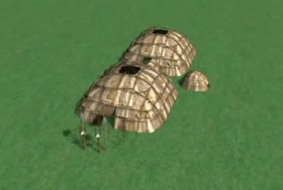
A few hundred feet to the southeast from the ring (though not visible today) is where Baby also found evidence of a large rectangular building, 120 feet long, with rounded corners. It suggests other known Hopewell-era Ceremonial Halls, like those at Liberty and Seip. The prepared, two-thousand-year-old floor was littered with broken pottery, stone tools, and flint chips; pits were filled with the debris from flintknapping. The Museum’s reconstruction model shows a structural framework of buttressed tree-trunks, set in the ground, and covered with sheets of bark or skins.
In the park’s southern meadow stands the best preserved of Ohio’s small, ancient earthen rings.
 BAKER FORK GORGE
The Gorge Trail branches off the Fort Trail beneath the southeastern prow of the earthwork, and winds down into the deep, limestone crevice created by Baker Fork. The plant life changes to those favoring these sheer rock cliffs. The trail climbs and descends several promontories, offering views of the river and rock formations from both above and below. Tree-roots cling to cliff-faces high above stone arches and waterfalls. The trail follows the river all they way around the base of the earthwork’s hilltop. At points the steep, human-made rim of the hilltop is visible high above. The trail passes through the shell of a preserved log cabin, before returning to the museum and parking lot from the northwest.
Meanwhile, the Deer Trail cuts additional loops farther into the forests, across Baker Fork, and among the nearby ridges and ravines.
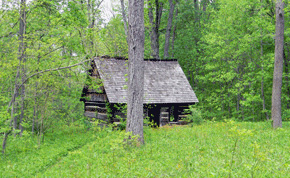
Far along on the Gorge Trail, the footpath passes through the shell of a preserved log cabin.
 HIKING FORT HILL
Fort Hill is an amazing experience, and a well-kept secret. The combination of adventurous hiking, glorious scenery, and ancient earthen architecture is unparalleled. Both the architecture and the distinctive ecosystem are exceptionally well preserved. Arc of Appalachia Director Nancy Stranahan explains:
The trees are magnificent, large; the ravines are true primeval in quality. I’m careful to throw out the word “sacred site”… but I will tell you this, when I walk up into Fort Hill, I feel a living presence. But I am not alone, there are many, many people who trek those trails and they come back and they just go, “I don’t know, but wow.” And when you look out over those hills from the lookouts, and you just see curve after curve of hill intersecting in the blue, something happens. When you get up to the top of the Fort itself and you look out of the lookout and you see the immense, immense, incomprehensible work that it took to create these earthen walls, on top of a ridge, you kind of go into a state of disbelief, and you move into awe and wonder.
 THE ARC OF APPALACHIA PRESERVE
Between Fort Hill and Bainbridge, you will be among various land holdings that comprise the Arc of Appalachia Preserve region: preserved forest lands filled with springs, caves, rare plants, and surprising rock cliff formations. Their headquarters is at the Highlands Nature Sanctuary and the Appalachian Forest Museum, 7660 Cave Road, Bainbridge, OH 45612, between Barretts Mills and The Point; phone: 937-365-1935.
Since 1995, the Arc has been acquiring and reuniting south-central Ohio forest lands for preservation – with the help of many dedicated supporters, donors, and volunteers. The efforts have steadily grown. Arc Director Nancy Stranahan:
The miracle is how many people rose to the vision. I would say probably about 1000 households are what have put the sanctuary on the map. And we have about 2000 acres here, and about 5 years ago the Highlands Nature Sanctuary idea spread to 13 other preserves. We now have 14 preserves in a 5 county area in southern Ohio, helping to keep green in Ohio’s future for our children’s children’s children. We either do it now, or it’s not going to happen.
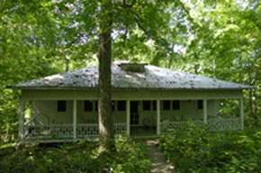
The Arc of Appalachia has historic lodgings for rent among its many preserved land holdings.
 THE FOREST MUSEUM
A new museum at the Arc’s headquarters was completed in 2010. Its mission is to tell the story of the eastern broadleaf forests of the US, now torn into tiny shreds by settlement, agriculture, and development. That huge single forest is an idea people need help to understand, to identify with, and to help preserve. Arc Director Stranahan explains:
This is one forest. The Temperate Broadleaf Forest covers the eastern third of our continent. That biome is the most disturbed of the earth’s 14 biomes: more in peril than the tropical rainforests, even the Boreal forest, even the prairies. So this incredibly disturbed system worldwide is one we want to bring citizen awareness too. The Appalachian Forest Museum is a place where in 15 minutes we’re going to get this concept across to people: that they belong to something, that it is special beyond measure, that much has been lost, and it is our job to restore, connect, and reunite.

Murals in the Arc’s Museum depict the temperate forest and its ecosystems.
 ROCKY FORK GORGE
From its museum and headquarters on the rim of Rocky Fork Gorge, The Arc of Appalachia Preserve System runs educational programs, rents out historic lodgings, and encourages land stewardship and preservation. Its scenic hiking trails are a popular destination:
The Rocky Fork Gorge is a 100 feet deep vertical walled limestone gorge, with a very clear river running through it, and it has phenomenal rock formations. It’s the second densest cave system in Ohio. And then there are all kinds of rock formations: big boulders midstream, tipping boulders that you’re walking underneath, so it’s a labyrinth of rocks that’s really beautiful. But in the summer you’re getting tremendous bird life, animal life. For avid hikers there’s back country trails that also go out to other sections of the Rocky Fork Chasm – we actually have 14 miles altogether.
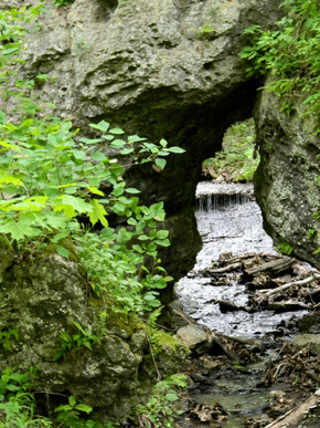
At Sulfur Creek, along the Gorge Trail, a stone arch frames a waterfall, beneath high cliffs.
 THE ANCIENT FOREST
These preserved nature sanctuaries sit among spectacular ancient earthworks: not only Serpent Mound and Fort Hill, but also the huge geometrics of the Paint Creek Valley. Nancy Stranahan talks about how the ancient earthworks and their builders add meaning to this spectacular landscape legacy:
We know their presence. We feel the honor and the obligation to take care of the land and maintain the landscape. For these people it wasn’t a postcard, it wasn’t a nature preserve, it wasn’t wilderness, it was their home. It was their community. They were part of that tapestry. Our organization is partly here because of the inspiration of the people that came before us. We want to not only maintain the memory of those people, and the history of those people, and the speculations of what they might be able to teach us if they were here today, but we also want to maintain their landscape.
Here where we live, in the Paint Creek Valley, we really feel like we live in the Valley of the Kings. Everywhere we go, we’re walking in their footsteps.
Play video
Seneca-Cayuga artist Alex Davis describes ongoing Native reverence for the Creator and Mother Earth (Owinsagay).
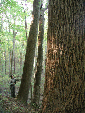
Giant old-growth trees make for beautiful hiking and wildlife habitat all seasons of the year.
 PAINT CREEK VALLEY
Bainbridge marks the western end of the beautiful Paint Valley, in antiquity an especially close concentration of geometric earthworks, including Seip, Baum, and, along its northern fork, the spectacular Hopewell Mound Group.
In Bainbridge stop at Paxton’s for lunch, and check on the world famous cheesecakes made across the street. An extensive antique marketplace is on a sidestreet nearby. The town may be best known as the birthplace of American Dentistry: the story is told in a small, white house, the Dental Museum, on Main Street.
 SEIP EARTHWORKS
Just outside of Bainbridge to the east, lies the Seip Earthworks, where the large mound is a reconstruction after extensive excavations. Beneath lay the post-mold pattern of a huge, multi-chambered timber building, with a precise, perfectly-symmetrical, temple-like floor plan almost identical to another at the Liberty Earthworks nearby south of Chillicothe. Elaborate, pearl-drenched burials and beautiful oversized effigy smoking pipes were found. Today visitors pass between two small segments of the surrounding geometric wall, which originally consisted of two large circular segments and a perfect square. From the top of mound, one can begin to imagine the surrounding figures, and their spatial relationships with the Valley.
Here in the lovely Paint Creek Valley, the hills form a natural amphitheater around the Seip Earthworks. A community of perhaps two hundred people used this site over several generations as a civic and ceremonial center. Over time they erected two great halls, several specialized buildings, and the huge enclosure. The square may have been used to monitor the movements of the sun. And this three-part pattern suggests a relation between the community at Seip, and the people at four similar sites in the region.
 M’SIKAMEKWI AND GREAT TOMB
The Shawnee people, like other Eastern Woodland tribes, have a special name for a building or ground used for ceremonies: “M’sikamekwi,” Big House Framework. The word suits the great hall built here, 113 feet long, precise and symmetrical in its layout, and nearly identical to another at the Liberty Earthworks, nearby in the Scioto Valley. Each of its three sections was apparently used by a different social group within the society. There were probably many activities and ceremonies that took place in here, we know that ritual burning and burial were among them. Among the few unburned burials were four young adults and two infants, placed together in a large common tomb and surrounded by thousands of fresh water pearls.
 THE GREAT TOMB
Most people buried on this floor were cremated first. Among the few to be laid out unburned were four young adults and two infants, placed together in a large common tomb and surrounded by thousands of freshwater pearls.
One theory suggests that among them was a vital leader, whose death required that the others be sent to their deaths, too. This grand burial may have been the last at the M’sikamekwi, for the tomb was marked twice after the building was dismantled and mounding began. On three feet of clay, five oversized pipes (brought from far away) were offered, perhaps as guardians. Many feet higher, on the primary stage of mounding, a printed fabric canopy was pegged down, over the tomb’s location. Finally, more earth was added to create the final memorial, thirty-two feet high and about two-hundred-fifty feet long.
 SEIP AND BAUM
A few miles east of Seip Earth-works, along Paint Creek, lies a similar site called Baum. Archaeologist N’omi Greber:
One of the remarkable things about Seip, this huge circle, medium sized circle, and big square, is that within practically eyesight there’s another very large earthwork that has a very similar design, and they are in a sense mates; but the land within and around them was used somewhat differently. However, they are, look as if they had been designed by the same architect, and possibly made by the same engineering crew. It’s remarkable to have two such huge, it’s like having two great cathedrals next to each other, but perhaps one being St. Joseph, and one being St. John.
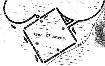
Within eleven miles of Seip were four other sites with remarkable similarties, all designed with almost identical principles, very likely by the same experts. Frankfort, to the north, Baum, nearby along the valley, and Works East and Liberty over in the Scioto Valley, south of Chillicothe. All five are composed of three main parts: a forty-acre circle, a twenty-seven acre square, and an eleven-acre circle. Each one also has some infill space, which although different in all five, brings the total area of each to an identical seventy-eight acres. Identical squares also are at nearby Hopewell, and far away Marietta. Archaeologist Warren De Boer speculates that these exactly duplicated shapes correspond to traditions of “winter” and “summer” houses, which even in historic Indian times are round, and square, respectively. And the three-part composition corresponds to the Big Houses. One new feature here are the openings in the walls of the bigger circles: this, and the more complex combinations, suggest new social patterns, because of their precise correspondences, they may be the latest of all the Hopewell-era geometric enclosures.
 VIEW FROM SEIP
Baum lies exactly where the valley seems to close up, four miles to the east. The Baum earthworks were across the river from the village of Bourneville, and traceable on aerial photos as late as the 1980s. Today they are invisible from ground level, and yet it is still possible to admire the Hopewell genius at marking out monumental geometric space within the bounds of these lovely hills, and to wonder at their placement of two such similar complexes literally within sight of each other along the river.
Atop the steep, prominent hill just east of the Baum site lies Spruce Hill Fort, a stone-walled hilltop enclosure even larger than Fort Ancient, and just recently acquired and placed under the management of the Hopewell Culture National Historical Park. Access is via a steep climb from its eastern flank, along Black Run Road, which may be arranged by contacting the Arc of Appalachia Preserve for a permit (937-365-1935), or checking in at the National Park’s headquarters at Mound City (or its web site) for the times and dates of periodic ranger-escorted tours.
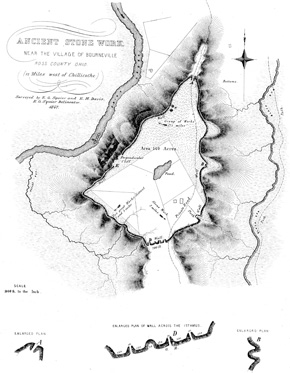
Spruce Hill Fort, Squier and Davis Drawing
 BOURNEVILLE; VIRGINIA MANSIONS
Along the valley near Bourneville stand several very grand old mansions, some built of brick and some in the local Waverly sandstone. Their architectural features and proportions derive from 18th century Virginia, reflecting the architectural tastes as well as the agricultural practices of their builders. These wealthy, post-Revolutionary War landowners in the new “Virginia Military District” ran vast estates, often with indentured servants, and sent their abundant crops and livestock to the nearby economic hub of Chillicothe.
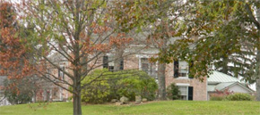
A Virginia-style mansion stands at the edge of the village of Bourneville, once anchoring a huge estate
 HOPEWELL MOUND GROUP
About 3½ miles west of downtown Chillicothe, turn northwest on Anderson Station Road where, after 2½ miles, a large open field on the right will be the site of the brilliant Hopewell Mound Group. For its astonishing complexity and spectacular artifacts, this became the “type site” of the entire culture, as defined by archaeologists. It may be visited as part of Hopewell Culture National Historical Park. Though subtle today, the wide profile of the large, 3-lobed mound (re-arranged after excavations) can be detected in the large field to the right of the road; a new trail leads to the surviving walls and ditches that survive intact across the hilltop to the north, and that still retain water as was likely intended by their makers (as at Fort Ancient).
The huge irregular enclosure contained many rings and mounds, some of earlier Adena origin, and some still being discovered by National Park staff’s remote-sensing methods. The red-soiled perfect square (likely a later addition to the design) is too worn down by agriculture to be visible on the ground today, but begins just west of the small parking area.
Hopewell Mound Group reconstruction, showing its composite design: part geometric, part hilltop, part irregular, and with many mounds and interior enclosures.
 THE RED SQUARE
Some time after the great enclosure was built, the Hopewell laid out a huge square, here to the northeast. As at other sites nearby, the square was noticeably red. Dr. Edwin Davis, in 1845:
The wall of the square is wholly of clay, and its outlines may be easily traced by the eye, from a distance, by its color… That [the walls] have been subjected to the action of fire, is too obvious to admit of doubt.
 THE CEREMONIAL CENTER
On this level part of the site, Hopewell people planned their largest ceremonial space. First, they scraped away grass and earth to reach a clay layer. They mixed clay and water to create a very hard floor surface. It’s been called “Hopewell concrete!” No one yet knows what features were built here first. But over several generations, people were performing ceremonial rituals here. They dug pits and built fires. They covered certain areas with stones, or multi-colored clay. Buildings large and small were erected here, to shelter or enclose the ceremonies. They brought many precious things to the site, often breaking and burning them before placing them in ritual deposits. Two of these were so large they are called “The Great Deposits.” And, people were buried here: one hundred and two in all just within this single, ceremonial space.
 BURIALS AND SOCIAL STRUCTURE
The people buried here at the ceremonial center were attended with the fullest ritual and care. Although the early archaeologists’ excavations of these special places cannot be undone, their records, and the artifacts, tell us much about the people, and their ways of life and death. Some of the burials were first burned in another location, then the remaining ash and bone swept together and re-deposited here. Most were buried unburned, though, stretched out in log tombs. Inside buildings, some of the tombs were covered with mounds. It’s possible that burying, mounding, burning, and depositing precious objects were all going on at once: a concentrated mix of human effort and vision with the elements of earth and fire.
About eighty of the graves under the Great Mound at Hopewell were in three large groups. These may have been kin groups, or clans, each with a respected place in the community. The nonperishable metals, stones, bone, and shells that survive were distributed widely, suggesting that there was not just one single, important person here. Each of the three groups included a few leaders, a larger number of people with some importance or special duties, and others without any particular prestige. And, with plain graves right next to elaborate ones, it seems that there were not strong class divisions. In many societies, only the most powerful would be buried within such an important ceremonial center.