
Fort Ancient
 ABOUT THE SITE
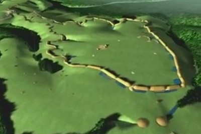
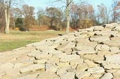
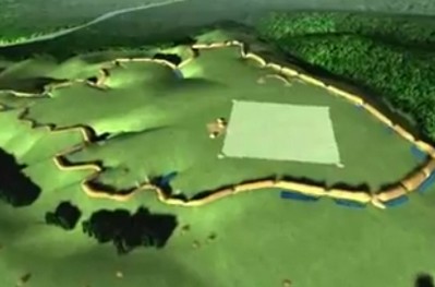
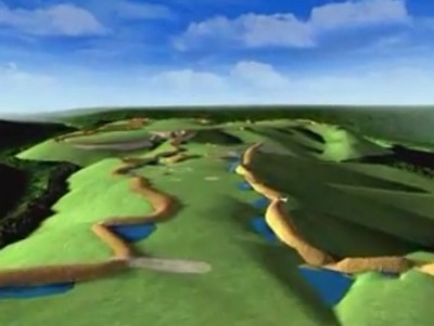
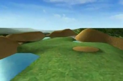
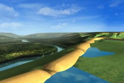
The most spectacular and well-preserved of the Hopewell-era hilltop enclosures, Fort Ancient encloses over 100 acres high above a narrow gorge of the Little Miami River. Here, Hopewell era builders moved massive amounts of earth to create complex and monumental spatial effects. The southern plateau was ringed first, then connected by a passage to a larger area, to the north. In addition to creating a continuous perimeter ditch-and-wall design, the builders moved soil to bridge across even the steepest ravines. When constructing the huge causeway across from the South Fort to the North Fort, for example, they filled up three gullies, using an amount of soil equal to all of the site’s earthen walls combined.
Early settlers, astonished by the place, decided it must be a fort. Yet no fort ever had 67 gateway openings or a moat on the inside. Today, Fort Ancient and other hilltop enclosures like it are thought to have been places of special ceremony, their elevation perhaps signaling their relation to the sky.
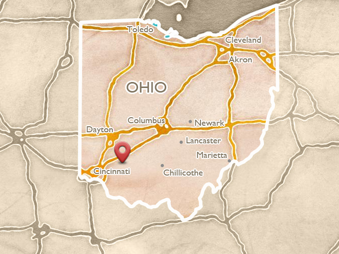
To reach Fort Ancient, take Exit 32 on Interstate 71 and head south, turning immediately left on State Route 350. (From the north, use Exit 36, and follow the signs.) In less than 3 miles, the road drops into the steep wooded gorge of the Little Miami River, passes an old schoolhouse structure on the right, and crosses the river. At the top of the bluff on the other side, the road passes directly through one of Fort Ancient’s 67 gateways and enters the broad, open North Fort. A small crescent, and the undulating walls, are visible on the left.
The excellent Museum and Visitors Center (513-932-4421) provides an overview of the site and Ohio’s Indian cultures through the time of European contact. A garden and reconstructed Hopewell era house help visitors envision everyday life for the earthwork builders. A complete walking tour of the site, including many of its outstanding features, will take three to four hours.
Hiking, biking, and canoeing facilities are available just below Fort Ancient beside the river. Upstream, the village of Oregonia has a café popular with people on the riverside hike/bike trail.

Play video
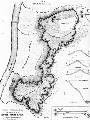
This 1848 map of Fort Ancient appeared in Squier and Davis’ Ancient Monuments of the Mississippi Valley.
 NORTH GATE AND TWIN MOUNDS
From the parking lot, walk on the lane (blocked to cars) that passes through the east walls, to gain a good view of the large Twin Mounds which frame the ancient North Gate, where today’s State Route 350 runs. These mounds are markers only, and seem to be a variation on the earthwork’s older gates which feature mound-like rises of the walls on either side. From here, parallel walls once headed out to the northeast, for about a quarter of a mile. They followed the highest elevation of the plateau, to where a small mound once stood, just beyond Middleboro Road. Dr. Patricia Essenpreis discovered in 1990 that from each of the Twin Mounds, the Ancients dug deep trenches out toward the nearby streams: filling with spring water, they completed a “water boundary” for the entire earthwork.
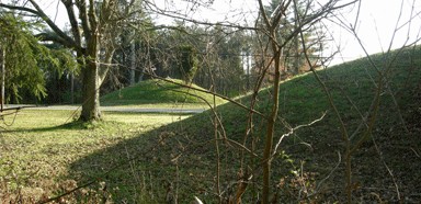
In ancient times, the Twin Mounds framed the start of a long, stone-paved roadway toward the northeast.
 FORT ANCIENT'S MOUNDS
Fort Ancient is designed mainly with earthen walls, gateways, and ponds, though there are a variety of mounds as well. Archaeologist Robert Connolly explains their roles in the design:
Very few of the mounds at Fort Ancient contained burials. They may have been used for signal fires as in the North Fort: Moorehead in the 1890’s reported that these were basically large piles of limestone that were very heavily burnt. We also know that mounds marked the entryways of primary gateways into the enclosure, and really were sort of a signaling device: people would see the large Twin Mounds (for example) and say, ‘Oh that’s the appropriate place to enter the earthwork complex.’ So the function of the mounds here at Fort Ancient was much beyond that of simply burying the deceased kin.
 THE FOURSQUARE
Four low, limestone-covered mounds form a perfect square inside the North Fort, 512 feet on each side. Their original limestone coverings had been heavily burned: it was oxidized, red, and crumbly; and the fossils in it had turned white. Huge fires had been set atop these stone-surfaced mounds, obviously for some dramatic, ritual purpose. This perfectly-defined, fire-demarcated square space seems to have been kept absolutely clean and free of buildings, suggesting it was sacred.
Trees would have been cleared to allow clear views from the western stone mound to the three, key astronomical alignments, through the gateways and out to the northeastern horizon. Today, the solstice gateway opening (just north of the highway) is kept clear. Site archaeologist Jack Blosser talks about Native participation in solar calendar events:
We’ve had some people of Native descent come to the grounds, and they perform their own specific ceremony they’ve been taught through their traditions. One year we had a winter solstice, and we had an elder with two helpers: the sun was obviously not going to come out, and he said, “Be quiet and listen.” He proceeded to get his equipment out. The helpers twisted the leather between their staffs and the elder had another staff and at the right time he began his prayers. And you knew it was the right time, because if you looked, you could see a very light shadow from the staff to the leather.
Play video
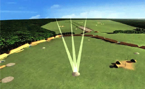
From the western stone mound, gateway alignments mark the summer solstice sunrise, and the minimum and maximum northern moonrises.

Play video
 HABITATIONS
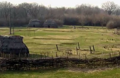
Evidence suggests that many people lived at or near Fort Ancient, over many centuries. Inside the enclosure, houses were found from the same period of time that the walls were being built. Everyday dwellings apparently existed within the sacred enclosure, but never crossed the line into the Foursquare area. These people also lived outside the enclosure, out to the northeast where the craft shops have been discovered.
The western arm of the South Fort was the primary occupation area for the later societies who lived here. At least off and on, between ll00 and 1550, there was a village here with a wooden stockade around it. These later people also had settlements down in the valley. But they had gone before the first pioneers arrived.
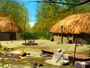
Computer reconstructed houses based on those found at Fort Ancient near the museum.
 THE MOOREHEAD CIRCLE
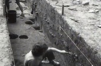
The biggest discovery at Fort Ancient in recent memory is a giant “woodhenge” in the North Fort, now called The Moorehead Circle. In summer, you may see members of a field school continuing the dig, across the road west of the museum. Jack Blosser explains how this ancient stone and timber work was first discovered:
We received a Save America’s Treasures grant in two-thousand-five: they were able to pick out stains in the soil that picked up a two-hundred foot in diameter circle.
Archaeologist Bob Riordan has been excavating here with his students every summer since then. He describes what was found, beginning with the ring of timber posts:
Very substantial posts set as deep as a meter in the ground, actually more than a meter because that’s a meter below the subsoil that we’ve started from. Some of them were set in place using ramps, so there would be shallow ramps. They would have to go out, cut trees, trim them, carry them in, set them in the ramps, and walk them upright. And then they filled the ramps with limestones, and chinked the posts with limestones as well.
At the center of this ring, Dr. Riordan found a pit containing a mound of astonishingly bright colored soil, perhaps the pulsing heartbeat of Fort Ancient:
So there’s this shallow pit, and in the middle of the shallow pit, a deeper pit, to the extent of about 70 centimeters below the surface: A red soil fills that pit. We’ve been presuming that this is a burned soil that was burned somewhere else; we’re not seeing lots of charcoal around it, under it, in it. It’s very, very clean, sterile red soil. So other people are thinking that it may be a more ancient soil that is naturally red that’s been brought in.
A set of parallel, stone-faced walks and gravel-filled trenches gather around this central feature. We know of nothing else like it in the Hopewell World. More mysteries are uncovered every year.
Play video
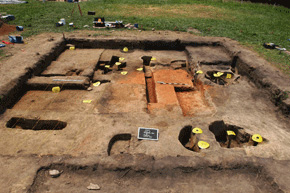
At the center of the circle of timber posts, a shallow pit contained bright red-orange, sterile, burned soil.
 BUILDING WITH EARTH AND STONE
Walk or drive south along the central road of the North Fort and notice the flat surface of the hilltop, with the walls on either side winding and narrowing toward the passageway approaching the Great Gate. To create Fort Ancient, generations of people must have worked toward a common goal. The first step would have been clearing the forests, a huge undertaking in itself. Then, they scraped soil off the surface, filled in ravines, and constructed 67 walls and gateways, plus 131 ponds. Finally they brought up limestone from the river valley below to reinforce the walls and gateways, to create stone rings and circles, to build long runs of pavements, and to surface much of the outsides of the walls.
 THE GREAT GATE
The most elaborate of the site’s three major passages is called the “Great Gateway.” The road rises to a narrow ridge, the original north entrance to the oldest part of the enclosure. Passing in and out along the ridge took the ancient visitors past mounds, crescents, and limestone pavements; as if to remember the first generations of ancient ancestors, perhaps the first who made this hilltop a sacred place, and a shared monument. The paired Crescent Mounds, one on each side of the road north of the Gate, help form this passage.
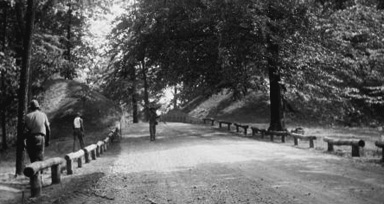
Historical image of the road as it approached from the outside of the older Great Gate; the walls swell into the form of two mounds.
 OVERLOOKS
The central road ends in a large parking lot past the picnic area. Turn right down the lane to reach the North Overlook, where a wooden platform offers views of the Little Miami River and its gorge. From here we can sense the special prominence of this location, and can appreciate the importance of creating an elevated sacred place, with such a strong visual tie the river below. A path with many stairs leads all the way down to the river and the hike-bike trail alongside it today.
Or, the terrace trail descends partway down the slope, to a series of large, ancient cuts in the hillside, then continues to the South Overlook. In April, the wildflowers there are abundant. Another, perimeter trail connects along the earthen walls from the North Overlook to the South Overlook: there, another wooden platform offers views of the wooded gorge below.
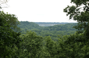
In ancient times, this view from the North Overlook would not have included the bridge for I-71; but today the extent of the river gorge remains breathtaking.
 SOUTH GATE
From the vicinity of the South Overlook, enter the nearby woods to reach perhaps Fort Ancient’s most spectacular feature: the grand South Gate.
All three of the major gates have similar features: a pair of mounds, together with ramps passing through a large gap in the walls. Like the Great Gateway, the South Gate opening was made higher by bringing the walls up, as if mounds were added to the top of the wall, although here it is of a much more massive scale.
A ramp bridges across the interior water-ditch. A stone pavement originally stretched all the way down the steep hillside to the river, suggesting grand processions: pilgrims, after a long journey, arriving by canoe, then climbing and entering the sacred enclosure; through the wall, past the mounds, and across the water.
 A NECKLACE OF PONDS
Fort Ancient was designed not only with earth but with water. The earthen walls obviously have the power to enclose space, but water was also part of this enclosing idea, helping to establish a sacred boundary. The clay-lined ditches along the interior were designed to fill with water and become an almost-continuous string of ponds, perhaps to evoke views or entries into the “watery beneath world” known from historical Indian traditions.
In antiquity, all visitors had to pass, not only through the wall’s gateways, but also across this water boundary, using a “land bridge.” The natural gullies that cut into the plateau were also blocked by continuing the walls across them. This created more ponds.
 KERN SERPENTS
About a thousand years after the walls of Fort Ancient were built, two small serpent effigies were laid down in the valley on the other side of the river, where today Camp Kern is located off State Route 350. The original limestone serpents remain safe underground, but it’s possible to see reconstructions built above them.
 FORT ANCIENT HISTORIES
The Hopewell era earthen monument that rings the hilltop is only one phase of the uses and histories of this site. Archaeologist Bob Connolly explains the long Native heritage here:
This plateau was actually used long before the construction of the Fort Ancient site, and after as well. We find artifacts here that date to as early as 5000 years B.C. In addition, the later, so-called “Fort Ancient Culture” occupied the South Fort around A. D. 1000 to 1200. What this points to is that this plateau was an extremely important part of the built environment of the Native American cultures for a five to seven thousand year period.
Around 1800, the first settlers quickly turned Fort Ancient into a tourist attraction. An early description was published back in Philadelphia in 1809. Caleb Atwater described it in his 1820 publication on Ohio Antiquities, earning praise from President Thomas Jefferson. An early highway cut through the northern section (State Route 350 today); and by the later 1800s, there was a railway stop and hotel at the bottom of the hill, beside the river.
The preservation of Fort Ancient was assured after archaeologist Warren Moorehead convinced the Ohio legislature to make it a State Memorial, in 1891. But it has seen many uses: while it was a World War I training camp, the troops practiced “storming the walls.” That’s probably the nearest it ever came to being a real fort!
Play video
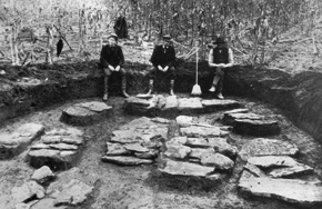
Ohio Historical Society archaeologist Warren King Moorehead (left in this photo) conducted extensive excavations at Fort Ancient in the late 1800s.